Finally, we reach the entryway to the park, the reason this series was begun four months ago. We hope you have enjoyed the little romp through the histories of the park, artesian well, pavilion, Winamac Conservation Club, and a major donor, Richard Rogers.
Now, finally, the entryway.
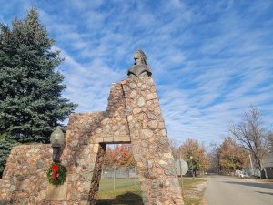
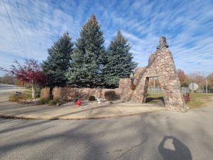
This gateway is beautiful. There are no other words for it. Well … graceful, majestic, historic … those words apply as well.
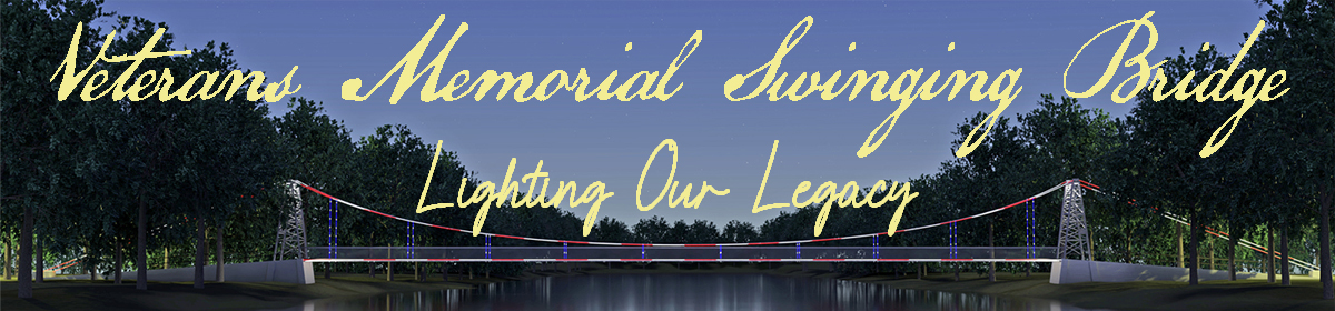
For those of us who live here, we tend to ignore it. We drive through it several times a year, on our way to the 4-H fair, the Power from the Past, reunions, picnics, walks, special trips to the Memorial Swinging Bridge, the playground, dog park … we drive through it to “do stuff,” but we don’t see it.
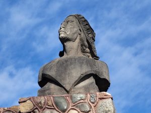
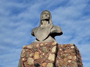
We don’t notice its graceful curves. We don’t look up to see the masterfully carved busts. I know an artist who painted the gateway and neglected to put the busts in the painting. Why? I’m not sure. Perhaps because he didn’t – as perhaps 90% of us don’t – look up? We don’t look up to take in the glory of this piece of art.
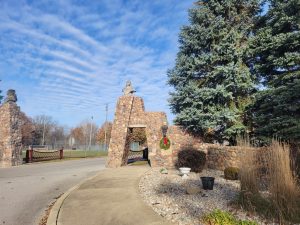
Very little has changed on the gateway since its erection in 1934, 88 years ago. It has been repaired, the ground around it landscaped, the electricity updated. It is certainly “shinier,” because in 2000 it was tuckpointed and sealed. Nothing else has changed. Oh … one thing changed, but it is something that was supposed to have been done in 1934. You’ll hear about that later in this piece.
Imagine the cost of reproducing this gateway today, including the multi-ton busts that adorn the top. Imagine finding an artist to donate his or her time and talents to the degree the gateway’s designer did. Imagine driving into this beautiful park without the benefit of the gateway.
If you remember the history as told to you in parts 1, 2 and 3 (February, March and April e-newsletters), you’ll remember that the peninsula was once a camping place for the Potawatomi, and that it has been a public space to one degree or another since white settlers moved in.
Access to the peninsula is limited. It can be reached by foot from the west by crossing the beautiful Memorial Swinging Bridge. The only other way in is through this gateway, which has both vehicular and pedestrian pathways.
Historic Information
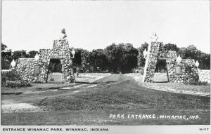
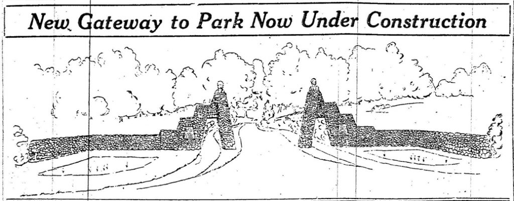
On February 15, 1934, the Pulaski County Democrat announced an artistic entrance that had been designed by a local man. It would be next to the State highway. Having an artistic entrance on a major thoroughfare would have been a feather in the caps of all persons living in the Winamac vicinity.
Signage still exists that points out “Old State Road 14,” but even so, it is hard to remember that for decades, a major highway passed through town and went past the entrance to the peninsula, an area that has been, since 1908, a private or public park. The highway curved around, following the river to a certain degree, but now, being a road that leaves town and enters the county, it seems more a meandering drive than a state-owned thoroughfare. It’s hard to imagine that the entryway to the park was visible to travelers from many states, driving east or west, from points in Ohio to points in Illinois.
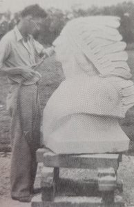
The article announcing the gateway described the use of large round rocks in its construction and “huge figures” to be carved from Indiana limestone. A local man, Russell Rearick, designed the gate and was to assist in the construction. He was to be the creator of the sculptures to adorn each side of the gate. The article described Rearick as a sculptor “of recognized ability, with a number of art prizes to his credit.”
The work was to be carried out as a Civil Works Administration (CWA) project.
Civil Works Administration (CWA)
Because we’re taking a trek through history, we’ll share a little about this program. The information contained here was taken from a piece written by Fred Zahrt in 1998, relying heavily upon Lynda Irving from the Pulaski County Public Library. She located a book that explained the program. Mr. Zahrt, in his document, explained the program in general.
We’ll leave out the politics.
Two months after FDR took office, he initiated a massive relief program to be administered through state and local agencies. It was called the Federal Emergency Relief Administration (FERA). The program spent millions of dollars, but in the end, it was not successful. Relief recipients were too proud to accept surplus commodities or wages for no work. The administration tried a different approach, resulting in the Civil Works Administration. This agency was strictly federal. It paid a wage rather than a relief stipend. In the two months in which it operated (February – March, 1934), jobs were created for four million men and women.
In that brief span, the CWA built or improved 255,000 miles of roads, 30,000 schools, more than 3,700 playgrounds and athletic fields, and a thousand airports. The program was terminated on March 31, 1934, for a number of reasons. The agency was closed down and the country reverted to direct relief.
It closed down before the gateway could be completed.
Frontage Information
Per the Pulaski County Democrat, the gateway had frontage of approximately 100 feet on the state highway – another document said 80 feet – I didn’t measure it – with two angles that set the main pillars back from the traffic lane. On either side of the main vehicle entrance was a narrow passage for pedestrians.
A new gravel drive was constructed the winter before, from the park entrance to a point north of the pavilion, which was still in its original location. It led along the riverbank on the east side of the peninsula, entirely removing the old drive through the middle of the park with “all its accompanying dangers.”
Other work was done by CWA employees included the construction of a driveway that would enable motorists to circle the entire tract while driving close to the riverbank. And aren’t we happy, now, that this driveway was done? How many times have you driven through the park, taking in the sights of the river on one side and the park on the other? Or walked along the drive? Someone had a good idea back then.
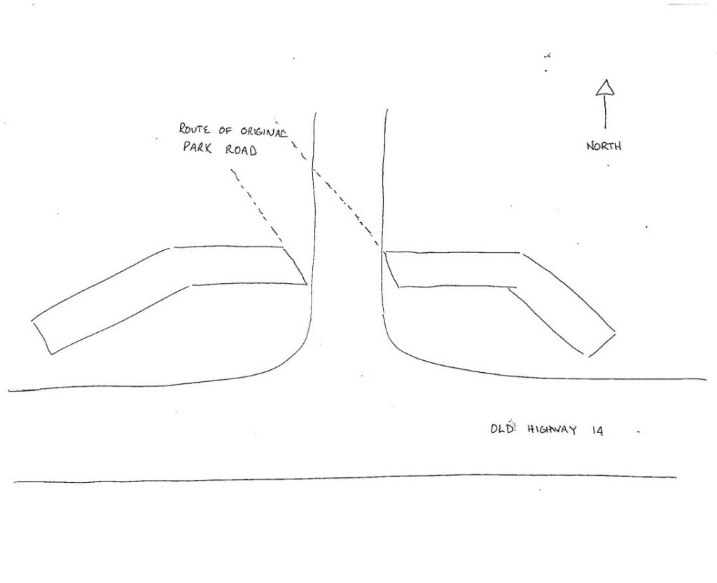
Back at the gateway, and noted in an article written by Fred Zahrt in 1998, if you stand inside the park and look south at the towers of the gateway, you will notice they are slanted. If you move west, they become parallel, marking the direction of the original road into the park. A drawing that he made to illustrate the slant appears here. It would be interesting to know how that worked. The CWA built the driveway that goes straight and then around the park, but apparently the “main” road still turned slightly to the left at the entrance.
Work Stops
The work stopped when the CWA program ended on March 31, 1934, about a month after the cornerstone was laid. Cold weather had delayed the work, and no one had counted on the CWA program ending as precipitously as it did. In the meantime, the Kiwanis club undertook the responsibility of assembling the material to be placed inside the cornerstone for posterity.
A Description of the Stone Gateway & Indian Statues
At some point, work resumed. Park funds were used, and the town was able to tap into township relief funds. Mr. Rearick, according to the Pulaski County Democrat, donated his time and talents in designing the gateway and sculpting the statues.
The Indiana limestone used for the busts, lintels and cornerstone was obtained through the courtesy of the Matthews Bros. Stone Co. of Bloomington, Indiana. This contribution was arranged by the chairman of the park board, James Dilts.
The blocks from which the statues were cut weighed about three and one-half tons before the carving began. (Another source said four and one-half tons.) Each bust is three feet and four inches high. They were delivered from Bloomington to the Dilts building on Pearl Street. Mr. Rearick completed the rough carving there, then moved them to the Rearick family home on West Street to complete.
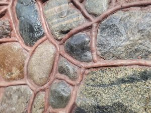
The stone pedestals upon which they stand are 14 feet in height. The stones used to construct the gateway were from Pulaski County fields.
The busts were described in the September 6, 1934 edition of the Pulaski County Democrat:
The Indians depicted in the two statues are of separate and distinct types.
The one to the west is an old chief with full head dress, in representation of the Potawatomie leaders who, bowing to the white man’s invasions, finally led their tribes away from the hunting grounds along the Tippecanoe. Tradition has it that the peninsula now forming the park was once a favorite Indian camping ground.
The one to the east … is a young brave wearing a single tattered feather. He represents the “common people” among the Indians, defiant and unbroken in spirit.
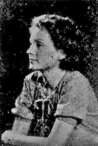
John Kocher, a local attorney, notes that that the model for the young brave was his aunt, Imogene “Gene” Huddleston Gast. At the time the carving was done, Gene would have been in high school. Gene died at a young age – not yet 29 – and a picture from her obituary is included here. The relationship is apparent.
Cornerstone
The Kiwanis Club gathered documents of interest to deposit at the laying of the cornerstone. They went inside a tin box made to fit the cavity in the stone. The documents were chosen to highlight the significance of the park to the community. The ceremony, which was supposed to be held on February 22, 1934, was delayed due to weather. This list was given of the items gathered.
-
-
- The original agreement under which thirty-five citizens set out their intention of forming a joint stock association to purchase the peninsula formed by the Tippecanoe River and convert it into a public park.
- The deed by which Benjamin and Dora Herrick transferred the property to trustees of the new association, dated April 10, 1908.
- The subscription list of the reorganized Park Association, which was formed in 1922 after the original association had expired. The list contained names of substantially all the original purchasers and several new ones.
- Another list of the names of all the stockholders in the association at the time the property was transferred to the Town of Winamac, executed on May 29, 1933.
- Original letters or copies of correspondence regarding the Rogers gift, which made the transfer possible.
- A copy of the trust agreement between Mr. Rogers and the First Union Bank & Trust Co. This agreement set out the payment by Mr. Rogers of the $1,135 debt against the park property and the establishment of a trust fund to be paid upon Mr. Rogers’ death. Proceeds of the trust fund were to be used for park beautification.
- Copies of the restrictions set up by Mr. Rogers. He stipulated that no person is ever to be denied admittance to the park on account of race, color, religion or politics. He also stipulated that no beer, wine, whiskey or other intoxicating liquor would ever be bartered, sold or given away on park property. There was also a provision that the town council was to cooperate with the Winamac Women’s Club and the Kiwanis Club in any beautification activities.
- A Resolution of Thanks adopted by the Kiwanis club on behalf of the citizens of the community in June of 1933, which was mailed to Mr. Rogers.
- Newspapers from the year 1908 detailing the formation of the original park association.
- Newspaper accounts of the dedication of the Memorial footbridge in 1923.
- Newspaper accounts from 1933 and 1934 detailing the Rogers offer, the final transfer of the property to the town, and the description of the gateway.
- Stationery printed in the 1880s from the Winamac Shooting Club and news of the club.
- A folder printed in 1907 showing pictures taken in the park, along the river and in the town.
- A photo taken of members of the Kiwanis club, with a list of its officers and members.
- Photographs of Mr. and Mrs. Rogers.
-
Fun fact: According to John Kocher, when the cornerstone documents were uncovered, he did not remember the year, all of the documents had been ruined.
Kiwanians Praise Rogers
At the Tuesday noon Kiwanis luncheon, former President Ralph E. Horner read and the club unanimously adopted the following resolution, which we believe expresses the sentiment of our entire community.
A Resolution: Sometimes we hear of a man who, in his later life, harks back in memory to the place of his nativity and to those with whom he formerly lived and prospered. We of Winamac have a concrete example of such a man in Richard S. (more familiarly and affectionately known as “Dick”) Rogers.
Compelled by ill health to seek another climate, after having spent almost the full allotted span of life in this community, an honored and respected citizen, he has been impelled to leave with us some memorial of his affection and regard. With the co-operation of the stockholders of the Winamac Park Association, he has made it possible for the beautiful peninsula of the Tippecanoe River to be retained and dedicated as a perpetual public park.
We, the Winamac Kiwanis Club, desire in this manner to extend to Richard S. Rogers our happy felicitations and the grateful appreciation of all our people for his splendid generosity.
Done this sixth day of June, A.D., 1933.
Winamac Republican, June 8, 1933
A Grant to Restore the Gateway
In 1998, the Kiwanis Club took the lead in writing a grant application to manage several upgrades to the gateway. The grant applications were successful, and several upgrades were made in 2000. The electricity was rewired and masonry work done to replace missing stones, tuckpoint and seal the work. A landscape architect was secured.
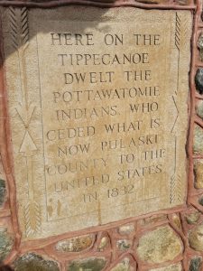
In Fred Zahrt’s presentation to the Club in favor of writing the grant (in 1998), he noted that now, 64 years later, the historic and dedicatory statements promised to Mr. Rogers were still missing from the gateway. The carving of those statements was included in an addition to the grant application.
A ceremony was held on September 9, 2000, on behalf of the Winamac Park Committee, the Town of Winamac, and the Winamac Kiwanis Club. Sixty-six years after the second of the Indian statues was lifted into place, the town could celebrate the renovation of the gateway and the completion of the original project.
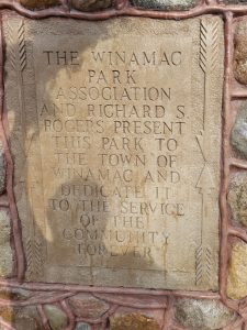
The statements promised in 1934 now read, on the east: Here on the Tippecanoe dwelt the Pottawatomie Indians, who ceded what is now Pulaski county to the United States in 1832. And on the west: The Winamac Park Association and Richard S. Rogers present this Park to the Town of Winamac and Dedicate it to the service of the community forever.
On a final note from Fred Zahrt, when the engraving was finally done, the wording was not correct. The Park Board made certain it was fixed.
Previously
March: Part 2: Artesian Well / West Side
April: Part 3: Pavilion, Winamac Conservation Club, Mr. Rogers Retires Park Debt